This is cross posted by Pesach Benson at the blog of Honest Reporting
In the middle of an article about a plan to relocate Bedouins, The Guardian‘s Harriet Sherwood worries that Maale Adumim might one day bisect the West Bank:
Many Palestinians see this as part of a strategic plan to close a ring of Jewish settlements that would cut East Jerusalem off from the West Bank. By stretching down to the Jordan valley, an expanded Ma’ale Adumim would also bisect the West Bank, making a contiguous Palestinian state impossible.
I’m not going to address the Bedouin issue – thats a separate discussion (which Sherwood and The Guardian have muddied before).
But as for her sense of geography, we heard the same hot air in 2005 over a parcel of land known as E-1.
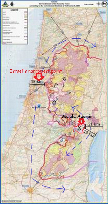
The inconvenient fact for Sherwood and her Palestinian fixers is this: Even if Maale Adumim morphed into a sprawling metropolis up to the borders of its designated area, the Palestinians would still have a waistline of nine miles (15 km) connecting their north and south. Our colleagues at CAMERA published this useful map making the very point.

To put it in perspective, the narrowest point of Israel’s waistline is the roughly nine km distance between Netanya and the Palestinian city of Tulkarm.
But who worries about Israel’s contiguity?
Related articles
- Harriet Sherwood’s report on Bedouin copy-pastes UNRWA anti-Israel propaganda (cifwatch.com)
- Palestinian Guardian propaganda photo of the day (Soldier vs. child) (cifwatch.com)
- Harriet Sherwood legitimizes Gazans’ complaints that they can’t enter Israel to sue the Jewish state (cifwatch.com)
- Peace activist’s home vandalized with death threats: Harriet Sherwood blames Bibi (cifwatch.com)


